



Garmin Fishfinders/GPS/Chartplotters & Network Systems

Navigate Smarter, Fish Harder: Fishfinders, GPS & Chartplotters Explained
Whether you're threading a channel in low visibility, hunting structure on a deep lake, or running offshore in open water, having the right marine electronics at the helm can mean the difference between a great day on the water and a dangerous one. Fishfinders, GPS units, chartplotters, and networked display systems form the backbone of any modern boat's navigation setup — and understanding what each does helps you choose the right combination for how you fish and cruise.
What Do These Devices Do?
Fishfinders use sonar technology to scan the water column beneath your hull, revealing fish, underwater structure, and bottom composition on a color display. Modern fishfinders go far beyond simple fish arches — advanced models support CHIRP sonar, ClearVü, and SideVü scanning to build near-photographic images of what lies below. Many also include built-in GPS so you can mark productive spots and return to them with precision.
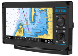
Chartplotters take marine navigation to the next level by overlaying your GPS position on detailed electronic charts of coastal waters, rivers, and inland lakes. Premium chartplotters serve as the central display hub of an onboard electronics system, combining detailed mapping, AIS overlays, radar, sonar, and even engine data into a single easy-to-read interface. Screen sizes range from compact 5-inch units to expansive 27-inch multifunction displays, with touchscreen, keypad, and hybrid control options to suit every helm layout.
Network systems elevate the single-unit approach into a fully integrated vessel-wide platform. Network-capable systems are able to work as a single station or with multiple displays networked together, sharing fishfinder data, radar imagery, AIS targets, and more across every screen simultaneously.
What to Consider When Shopping
- Screen size and resolution: Bigger screens and higher resolution make it easier to read sonar returns and chart details in bright sunlight.
- Sonar type: Entry-level units offer traditional CHIRP, while higher-end models add ClearVü and SideVü scanning for side and downward imaging.
- Chartplotter vs. combo unit: Dedicated fishfinders are simpler and more affordable; combo chartplotter/fishfinder units add full mapping capability and connectivity to other onboard gear.
- Networking capability: If you plan to add radar, autopilot, VHF radios, or a trolling motor, look for units that support NMEA 2000 or a manufacturer's proprietary network.
- Chart content: Many units come preloaded with coastal and inland charts, with options to upgrade to more detailed mapping subscriptions.
Top Brands in Marine Fishfinders, GPS & Chartplotters
Garmin is one of the most recognized names in marine electronics, offering a wide range of fishfinders and chartplotters spanning beginner-friendly STRIKER series units all the way up to the flagship GPSMAP multifunction displays. Garmin chartplotters are notable for deep integration across their ecosystem — units can sync with sonar, trolling motors, cameras, stereos, autopilots, and VHF radios — and many models come preloaded with Garmin Navionics+ charts featuring coastal and inland chart content with Auto Guidance+ technology.
Si-Tex has been a trusted name in professional and recreational marine electronics for decades, with products built around simplicity, performance, and reliability. Established nearly forty years ago and known for serving mariners worldwide, Si-Tex offers chartplotter/fishfinder combos designed for vessels ranging from center console skiffs to light commercial boats, with models featuring NMEA 0183 and NMEA 2000 connectivity for easy integration with other onboard systems.